MWNet v1.0 — AI precipitation nowcasting for the public

After two years of development, we present accurate short-time AI precipitation predictions available for the public in Central Europe.
During storm seasons, it is often possible to see a storm forming on the horizon. A natural question in this situation is: “Will that storm hit us? How severe will it be?” It always depends on the situation, whether finding an answer to these questions only increases comfort or protects human health and property. In Meteopress, we want to share weather information available to us with all those who need it to make well-informed decisions during severe weather events. In this work, we explore the use of machine learning (ML) in precipitation nowcasting and present Meteopress Weather Net (MWNet) — a neural network for high-resolution radar echo prediction.
Storms are generally very localized events both spatially (affected area) and temporally (duration). Single-cell thunderstorms typically last less than an hour with diameters around 20 km [1]. Thus, an effective forecast needs to be accurate and have high enough spatiotemporal resolution to capture the development of a storm.
Meteopress is a weather sensing and forecasting company. We are developing our own weather radars and radar network in Central Europe. Our radars, which are affordable yet reliable, allow us to accurately observe precipitation with 250 m spatial and 1-minute temporal resolution. While it is possible to predict storm development from this data manually, it requires experience and time. Thus, the scalability of this manual approach is too low to give a sound forecast to everyone who would benefit from it. We are computing Numerical Weather Prediction (NWP) models to create weather forecasts for several days ahead. However, the 2 km spatial resolution and 1-hour time step used in our models can not sufficiently describe a storm. Moreover, computation of NWP takes several hours, which does not allow the use of real-time data.
Using precipitation nowcasting and machine learning is one of the possible solutions to these problems. MWNet computes predictions in seconds on consumer-grade hardware, which allows it to rely on real-time weather radar measurements. It keeps resolution of the input data and achieves superior quantitative performance compared to other available nowcasting solutions.
Machine learning for precipitation nowcasting
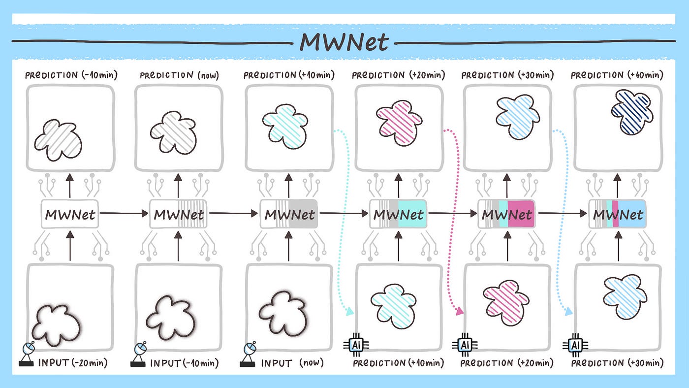
The expected result of any precipitation forecasting is the intensity of rainfall at a given place or area for a specified time in the future. To use machine learning, we formulate the forecasting as a regression learning problem on 2D precipitation fields, represented by weather radar measurements. The models are trained to predict a sequence of K future fields based on the last J measured ones.
The baseline ML building stone for processing 2D data is the process called convolution. In convolution, a 2D filter is slid across the whole input image, looking for the same feature at every part of the image. Convolutional neural networks (CNN) use these convolutional layers multiple times in a sequence, each with several learned filters, to extract the important high-level information from the input image. In radar echo prediction, the model needs to handle a sequence of 2D images, where the idea of recurrent neural networks (RNN) comes in handy. An RNN network has a state and processes the data sequentially, updating its state with each input image. Thus, RNN can theoretically utilize information from all previous time steps during prediction for the following one.
These building principles will probably change in the future due to the advances in transformer models, which are summarized in [2]. However, we have found the PredRNN architecture with Spatio-Temporal LSTM cells, proposed in [3], to be a suitable stepping-stone for this use case. We have based our first recurrent model MWNet v0.2 on it. While it achieved promising quantitative results, the predictions were very smoothed due to the pure regression formulation of the prediction task. It is challenging to correctly predict high-frequency features in the data, so a smoothed out prediction tends to result in lower errors.
Luckily, there is an understanding of the physical processes in the atmosphere and constraining the forecasts based on it could solve the smoothing problem. To test this hypothesis, we have incorporated the advances of the PhyDNet [4] into MWNet v1.0. The architecture framework disentangles dynamics governing the data into physical and residual parts. The physical one is modelled using partial differential equations (PDE) by a specially designed PhyCell. We will explore such fusion of physical and data-based modelling more in the near future, encouraged by the superior results of MWNet v1.0 in our evaluations.
Development of MWNet
All versions of MWNet have been trained on data from above the Czech Republic obtained through the OPERA programme by EUMETNET. The reason for not using our own radar data is the short historical archive. During the training phase, the neural network computes forecasts for past situations and learns to minimise the error between prediction and the correct outcome (ground truth), which is for the historical data already known.
We have used roughly five years of radar data with a spatial resolution of 1 km and time step 10 minutes. We have identified independent situations in the data and separated train, validation and test datasets according to them. We define two consecutive rainfall situations as independent if a minimum of 24 hours without rain separates them. The training set contains 275 of these situations. We have scaled the reflectivity radar data to support the stable performance of the model. Precisely, the reflectivity values (0, 60] dBZ are linearly mapped to (0., 1.], with the “no precipitation” value represented as 0. We kept the new scale in every part of the project.
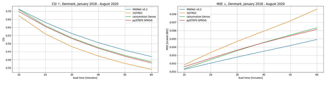
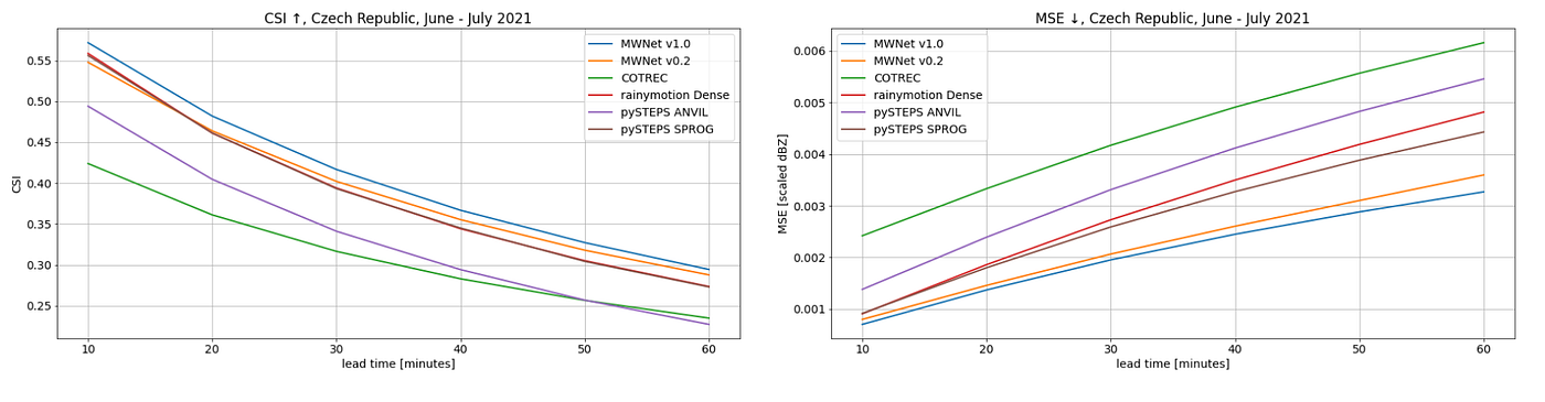
Precipitation nowcasting models predict both area and intensity of the rainfall. Thus, one metric often does not give comprehensive information about the quantitative spatiotemporal performance of the predictions. On the other hand, using too many metrics creates clutter in the evaluation data. We have experimented with several metrics, such as Fraction Skill Score (FSS) and Structure Amplitude Location (SAL). However, we have found the simple combination of Mean Squared Error (MSE, lower is better) and Critical Success Index (CSI, score in [0., 1.], higher is better) with a threshold of 9 dBZ to work well during MWNet development.
Experimental results
MWNet has been evaluated against precipitation nowcasting models based on the optical flow. These models operate in two steps — estimating the precipitation field's motion vectors (optical flow) from a sequence of the latest radar echo measurements and extrapolating to the future ones according to them. One of the popular ones is the COTREC method, which several national meteorological offices in Europe use. Others are available in the libraries pySTEPS and rainymotion.
We have done two case studies — for the Denmark domain between January 2018 and September 2020 on data provided by the Danish Meteorological Institute and the Czech Republic domain during June and July of 2021. The same Czech training dataset has been used in both cases, and predictions were computed for the 60 minutes lead time with 10 minutes time step. The performance metrics show that MWNet consistently achieves the best mean performance from the models in the comparison. The MSE of MWNet v1.0 on the Czech domain is 52 % lower than the COTREC’s one.
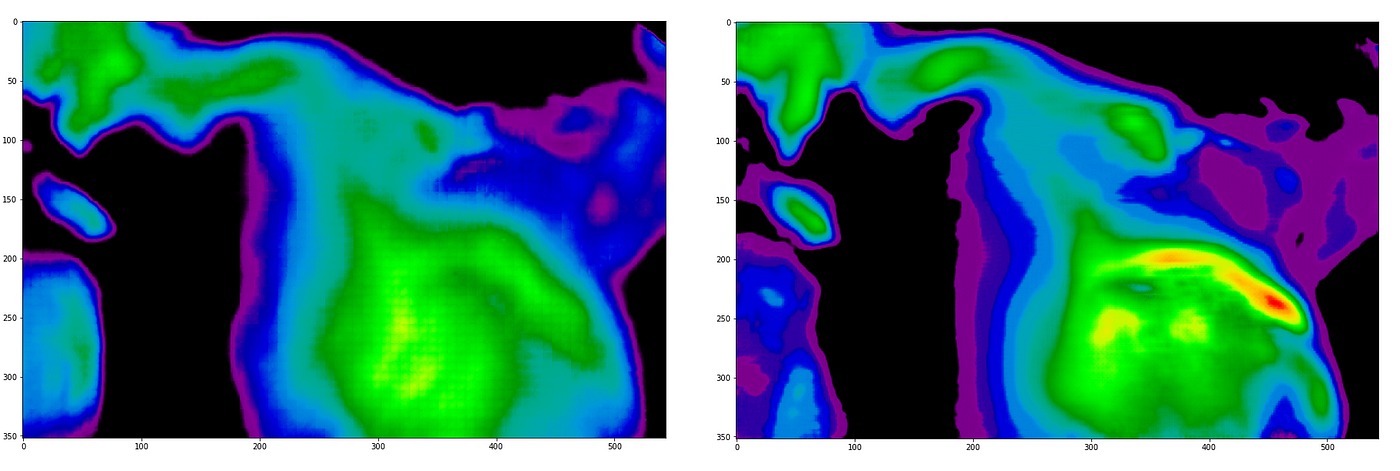
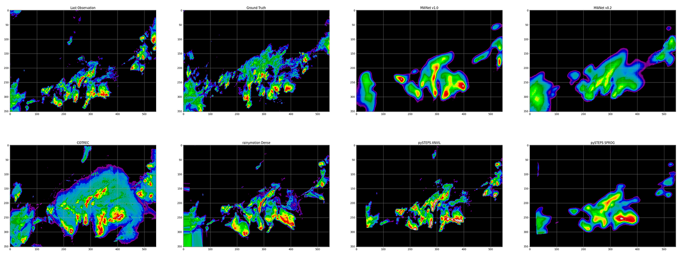
The figure below displays 60 minutes prediction visualization of every model in the comparison on the Czech domain. The last input precipitation field was observed on 24. June 2021 18:40 CEST, during the convective situation that included a tornado. MWNet v1.0 and pySTEPS ANVIL qualitatively predict the best position of storm cells. However, pySTEPS ANIVL indicates too many cells in this situation that creates clutter and false alarms.
Operational use
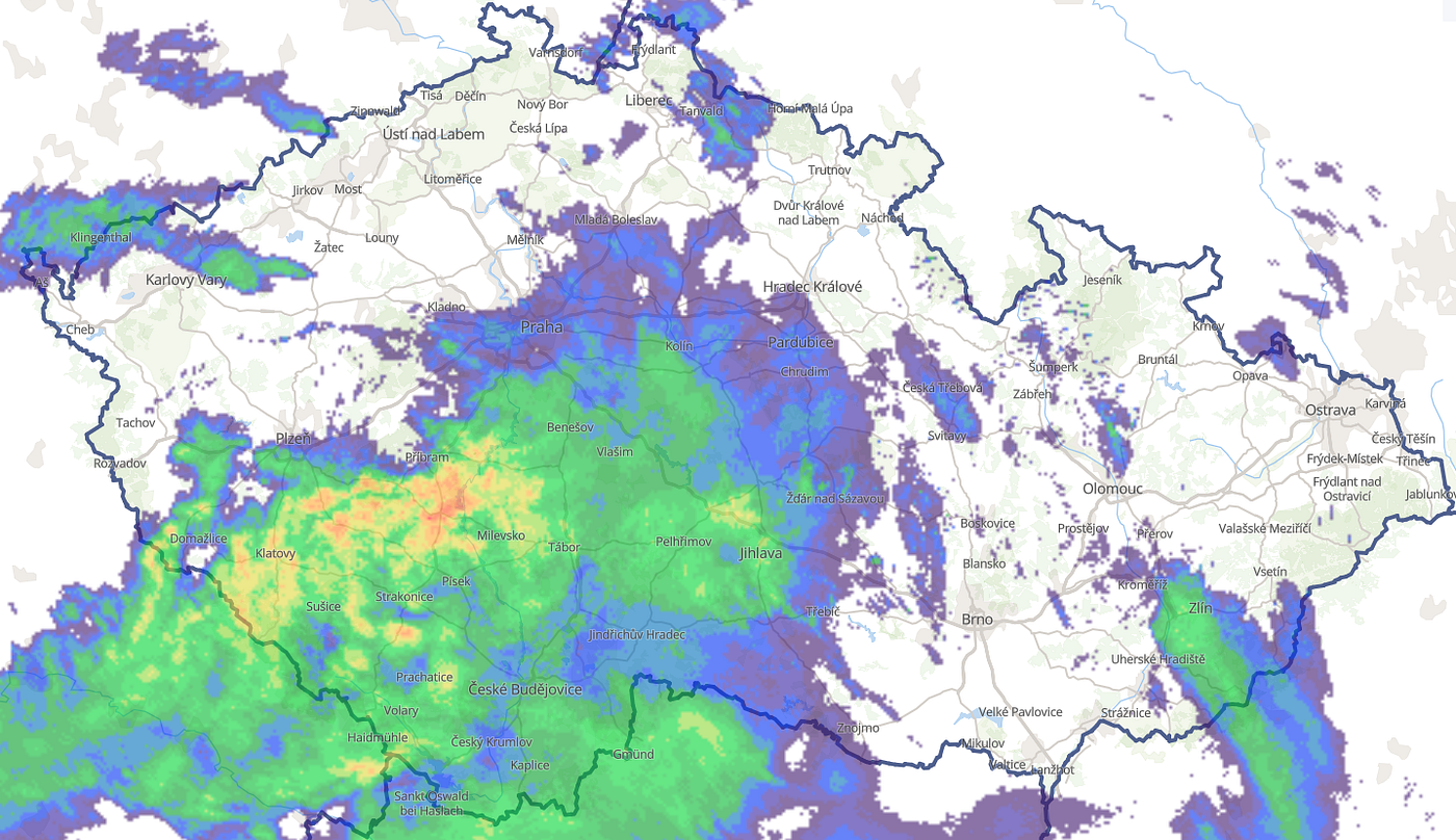
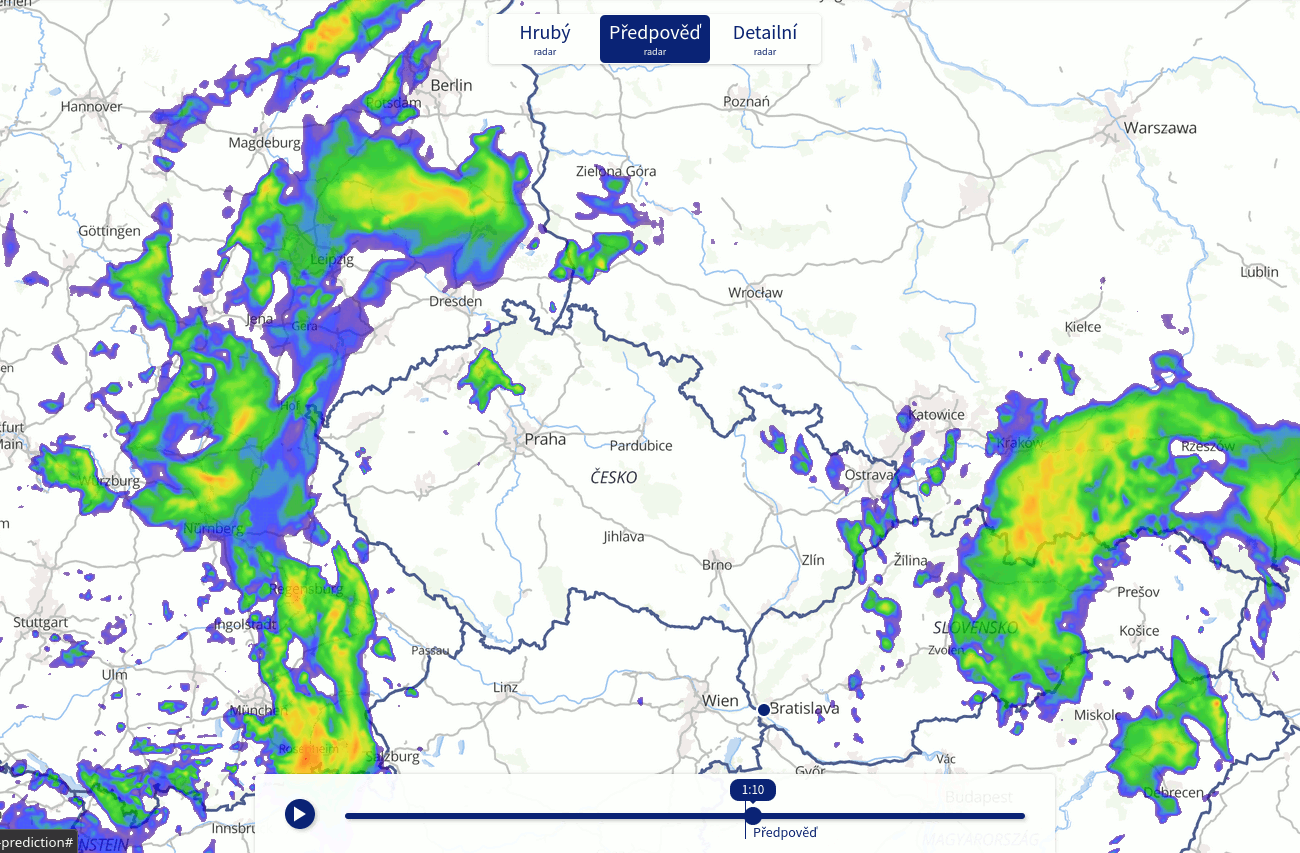
The vital part of this work is to deliver the best possible predictions to those who need them. Thus, we are continuously publishing our best currently available nowcasts on the website https://www.meteopress.cz/radar/?product=rad-prediction.
We run MWNet operationally on a consumer-grade GPU Nvidia GeForce RTX 2070. The predictions for up to 60 minutes are computed for the Central Europe region with a 1 km spatial resolution every 10 minutes. The computation takes approximately 6 seconds, and the predictions are available online in real-time.
What next?
The high quantitative performance achieved by pure ML nowcasting models comes with some caveats, mainly the lack of physics inside the model. It produces predictions that visually do not resemble reality and raises concerns in the expert meteorological community due to the low explainability of the forecasts.
Luckily, the MWNet v1.0, which uses PDEs to model part of the precipitation dynamics, achieves superior performance and improves some problems, e.g. smoothing out the forecasts. We believe that these fusions of physics-based modelling and ML may lead to many improvements in weather forecasting, and we will explore it more.